I. PLAN OBJECTIVES:
This plan consolidates within one document the current strategy, future focus, and established priorities for management of the San Dimas Experimental Forest (SDEF) by the Pacific Southwest Research Station (PSW) of the USDA Forest Service. It incorporates guidelines by reference and inclusion of portions of established planning documents to create an overall management framework. These documents include:
The SDEF Resource Monitoring Plan (RMP)
Fern Canyon Research Natural Area Plan (RNAP)
SDEF Facilities Management Plan (FMP)
PSW/Angeles National Forest Operations Plan (OP)
II. HISTORY AND GOALS OF THE SDEF:
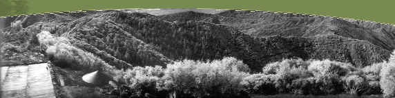
The San Dimas Experimental Forest (SDEF) is managed by the USDA Forest Service, Pacific Southwest Research Station, as a field laboratory for ecosystem studies in chaparral and related Mediterranean-climate ecosystems. From its establishment in 1933, the SDEF has been a center for hydrologic research in mountain watersheds. This research has included intensive monitoring of precipitation and water yield in mountainous terrain and studies that manipulated the natural vegetation across watersheds to maximize water yield. More recently research has emphasized the impact of wildland fire on watershed processes and air quality, the effects of chronic air pollution on stream-water quality and the biogeochemistry of nitrogen, processes and rates of soil development and erosion, patterns in plant community development, avian population dynamics, and remote sensing of fire and ecosystem processes. Research at the SDEF has developed an extensive database on chaparral ecology and mountain hydrology and climate.
The U.S. Man and the Biosphere Program has designated the SDEF as a Biosphere Reserve. SDEF also includes the Fern Canyon Research Natural Area, part of the Forest Service national reserve system.
Environmental monitoring at the SDEF currently includes collection of climate data; multi-spectral airborne remote sensing; measurement of stream flow, stream-water concentration and yield of nitrate, and watershed sediment yield; and observations of long-term trends in populations of neotropical birds.
Recent wildfires and prescribed burning on the SDEF have provided the beginning of a chaparral age-class mosaic, which is of value in studies of fire behavior, plant and animal community development, and ecosystem processes. Virtually all of the SDEF was burned during the Johnstone Fire of 1960. The Village Fire in 1985 subsequently burned Fern Canyon and the Upper East Fork watershed of San Dimas Canyon. Research prescribed fires in October 1984 burned chaparral throughout the 804 and 874 watersheds of Bell Canyon and the 775 and 776 watersheds of the West Fork of San Dimas Canyon. Prescribed fires also burned major portions of Lodi Canyon in December 1996 and June 1997.
The goal of the SDEF is to provide long-term, protected access to natural ecosystems typical of the front range of the San Gabriel Mountains for the conduct of natural-resource science and education. Compatible public uses may be permitted under strict regulation. The SDEF is available, with restrictions, for measurements and manipulation of the natural systems as well as long-term monitoring of ecosystem processes.
The SDEF shall be managed in accordance with prescription No. 20 of the Angeles National Forest Land and Resource Management Plan.
The natural environment within the Fern Canyon Research Natural Area shall be maintained in accordance with prescription No. 21 of the Angeles National Forest Land and Resource Management Plan and the Fern Canyon RNA Management Strategy.
Facilities at the SDEF include the historic Tanbark Flats research station; operating streamwater-discharge gauging stations in Bell and Volfe canyons; sediment-collection basins in Bell Canyon; a network of precipitation gauges; the historic Tanbark Flats lysimeters, which have recently been a focus of soil development studies; and a network of maintained roads and trails. Tanbark Flats facilities include living quarters and barracks, a small laboratory, mess hall, and shops. Non-maintained facilities for stream gauging are potentially restorable below small watersheds in Fern Canyon, lower Bell Canyon, and the West Fork of San Dimas Canyon and in the main Fern and Monroe canyons.
III. SDEF OBJECTIVES
Operating objectives of the SDEF are as follows:
- Provide a safe and healthful environment for science and natural-resource education in a vitally important Mediterranean-type ecosystem of southern California.
- Conduct long-term environmental monitoring both for detection of long-term ecosystem trends and as support to short-term research projects (see SDEF long-term monitoring element of this plan).
- Provide a diversity of age classes in native vegetation for ecosystem research.
- Minimize impacts of wildfire on research sites and facilities.
- Restrict vegetation manipulations or disturbance that result in loss of biodiversity of native species or encourage establishment or spread of non-native species.
- Minimize direct human impacts on scientific facilities, research, and natural resources.
- Maintain in good condition the historic facilities at Tanbark Flats.
- Maintain current road and trail access to experimental watersheds and sites in Bell, Volfe, San Dimas, and Fern canyons.
- Promote scientific and educational uses of the SDEF and its monitoring database consistent with its operating objectives and management direction.
- Maintain public assess, via the SDEF web site, to research and monitoring data, management plans, and research conclusions.
IV. SDEF LONG-TERM MONITORING
Environmental monitoring at the SDEF will be maintained according to the following schedule:
Element |
Objective |
Approach |
Climate and weather |
Provide a basis for hydrologic analyses at hourly to daily scales. |
Precipitation is measured by recording gauge at Tanbark Flats and at two elevations within Bell Canyon; air temperature, relative humidity, wind velocity and direction, & solar radiation are measured at Tanbark Flats. |
Stream-water discharge |
Determine inter-annual variation in stream response from chaparral and degraded watersheds. Assess effects of vegetation age and development on water yield. |
Flumes and v-notch weirs are operated at watersheds 801, 802, 803, & 804 in Bell Canyon and at Volfe Canyon. |
Stream-water nitrate concentration and discharge |
Determine long-term trends in nitrate yield from chaparral watersheds subject to chronic air pollution; assess effects of vegetation age and development on nitrate yield. |
Nitrate concentration is monitored in watersheds 803 and 804 in Bell Canyon and in Volfe Canyon. Sampling rates vary from 4 samples per day during storm flow to 2 samples per week during spring base flow. |
Remote sensing |
Provide multispectral imaging data to characterize long-term vegetation change. |
Annual coverage is provided with a multi-spectral visible, short-wave-infrared, and thermal-infrared imager and other high resolution digital photography as available. Minimum resolution of 2 to 5 meters is provided over Bell and Fern canyons. |
Avian populations |
Determine long-term trends in avian diversity in Mediterranean-type ecosystems with very low rates of direct human disturbance. |
Annually monitor transects in Fern Canyon RNA in Quercus chrysolepis and Pseudotsuga macrocarpa woodlands and in chaparral. |
Soil erosion |
Monitor long-term sediment yield from undisturbed watersheds. |
Measure sediment accumulation in four Bell Canyon debris basins after significant, annual-scale events. |
Vegetation biomass |
Determine long-term trends in chaparral biomass accumulation. |
Estimate at 3- to 5-year intervals the basal area and biomass on long-term real-growth plots in Ceanothus crassifolius chaparral. |
V. OPERATIONS
The Pacific Southwest Research Station (PSW) and Angeles National Forest (ANF) jointly manage the SDEF as shown below. Shared responsibility for a management task implies that both PSW and the ANF are involved with mutual concurrence for specific activities.
Management task |
Responsibility |
Maintain Tanbark Flats buildings and grounds (see SDEF Facility Master Plan). |
PSW |
Enforce closure to unregulated public access and post informational signing. |
shared |
| Maintain and rehabilitate fuel breaks. |
ANF with PSW concurrence |
Maintain telephone system (see SDEF Facility Master Plan). |
shared |
Maintain water, sewer, propane, and electrical systems (see SDEF Facility Master Plan). |
PSW |
Maintain and rehabilitate roads. |
ANF with PSW concurrence |
Maintain and rehabilitate trails. |
shared |
Maintain plantations and arboreta. |
shared |
Conduct law enforcement. |
ANF |
Manage and reduce fire hazards and conduct fire presuppression actions. |
shared |
Maintain research structures and instruments (see SDEF Monitoring Plan). |
PSW |
Administer special uses and administrative studies. |
ANF with PSW concurrence |
Conduct land management planning and environmental analyses. |
ANF |
Conduct fire prevention, protection, and suppression (see below). |
ANF |
Plan and implement prescribed burning. |
shared |
Manage the Fern Canyon Research Natural Area (see Fern Canyon Management Strategy). |
shared |
Cooperate with the UNESCO Man and Biosphere Program. |
shared |
Conduct engineering for new and restored facilities. |
shared |
Implement programs for environmental education. |
shared |
Administer limited, compatible recreation. |
ANF |
Protect watersheds and wildlife habitat. |
shared |
Manage habitat for threatened and endangered species. |
shared |
Protect cultural resources. |
shared |
VI. FIRE MANAGEMENT GUIDELINES
Fire suppression activities within the SDEF shall be conducted in accordance with the Light Hand Tactics Guide (FSM 2324.23.1) in order to minimize impacts on research. Specific prescriptions for minimum-impact fire suppression within the SDEF include the following:
- Hand construction of lines in chaparral areas and within oak woodlands is permitted. Soil disturbance should be minimized and later repaired.
- Use of aircraft for water drops is permitted. Retardant drops should be minimized. No helispots are to be constructed, except at the Tanbark Heliport and alternate sites along roadways.
- Use of heavy equipment (bulldozers) is to be discouraged, except for along established fuel breaks, along roads, and for protection of Tanbark facilities.
- Use of pumps, chainsaws, and generators is permitted. Pruning and selective felling of trees is permitted.
- No spike camps are to be constructed within the SDEF.
Post-fire rehabilitation shall be restricted to prudent repair of firebreaks, trails, roads, and drainages to minimize soil erosion from direct fire suppression activities. No post-fire rehabilitation of hillsides by seeding is permitted. No reforestation will be undertaken.
Back to Top