USDA Forest ServiceSkip navigational links    
 Pacific Southwest Research Station
 Pacific Southwest
Research Station
 About Us
 Contact Us
 FAQ'S
 Newsroom
 Publications & Products
 

>600 C

400 C

200 C

75 C

74 C

0 C


View the Cedar Fire in Google Earth.
Locations approximate.


Entire Northwest Sequence:

View the Cedar Fire Passes 2, 6, 9, 37 and 70 in Google Earth.
Locations approximate.
 

Entire Southwest Sequence:

View the Cedar Fire Passes 11, 12, 14, 15, 17, 29, 31, 33, 34, 36 and 68/69 in Google Earth.
Locations approximate.
 

Entire Western Sequence:

View the Cedar Fire Passes 6, 9, 17, 31, 29, 26, 25, 51, 59, and 53/54 in Google Earth.
Locations approximate.


Pacific Southwest Research Station
800 Buchanan Street
West Annex Building
Albany, CA 94710-0011

(510) 559-6300

 United States Department of Agriculture Forest Service. USDA logo which links to the department's national site. Forest Service logo which links to the agency's national site.


Fire Science: Wildfire Monitoring and Prediction


Fire Imaging: Cedar Fire
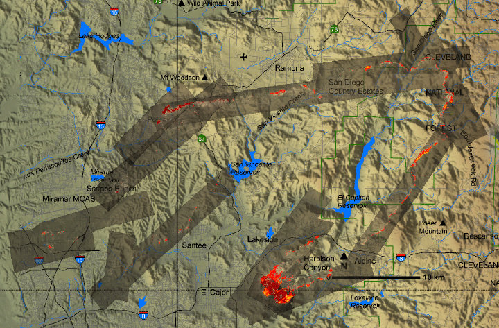
Cedar Fire, San Diego County, CA
26 October 2003 at 18:10


As viewed by the FireMapper™ Thermal-Imaging Radiometer


Click on the image above to view a larger Zoomify (JPEG) image
(opens a new browser window)

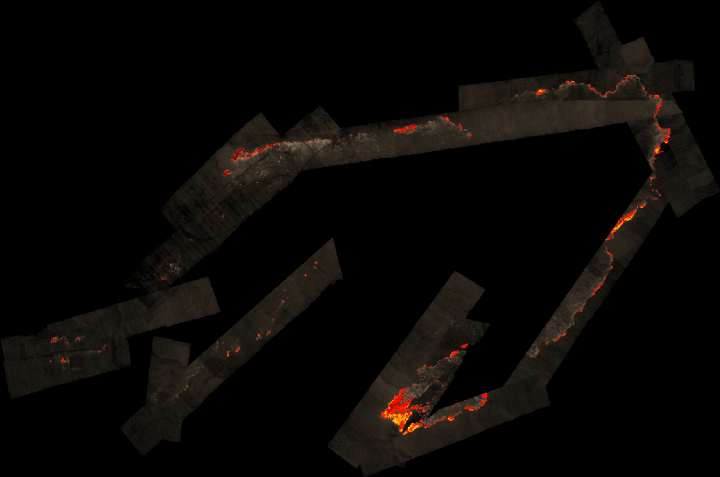
Current Image: Thermal mosaic
Ground surface temperatures as viewed from above at 8-12 micrometers wavelength on 26 October 2003, between 18:10 and 19:35 PDT.


Image 1: Thermal Mosaic
Plan view of fire. Warmer tones represent recent or active combustion; areas of light gray are cooling ash or warm bare ground and the low temperatures of unburned forest and cool ground are shown in darker gray (see chart above).


Click on the image above to view a larger JPEG image
(opens a new browser window)


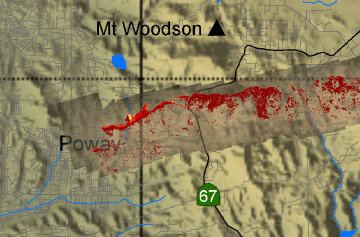
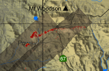
North set of repeat transects (near Poway)

Image 2: Mosaic Overlay
Firespread series: Pass 49 at 18:05


View the Cedar Fire Pass 49 in Google Earth.
Locations approximate.


Click on the image above to view a larger JPEG image
(opens a new browser window)


Image 2a: Mosaic Overlay
Firespread series: Passes 70, 71 at 19:27


View the Cedar Fire Pass 71 in Google Earth.
Locations approximate.


Click on the image above to view a larger JPEG image
(opens a new browser window)


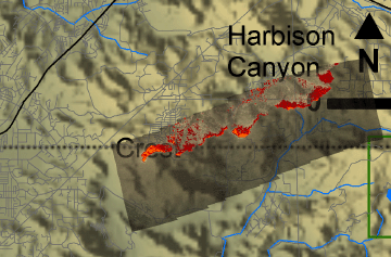
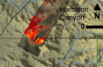
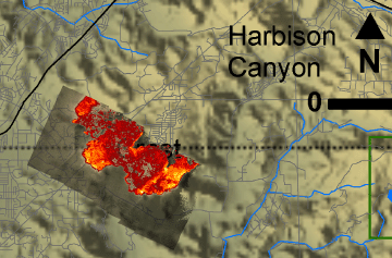
South set of repeat transects (near Crest)

Image 3: Mosaic Overlay
Firespread series: Pass 62 at 18:49


View the Cedar Fire Pass 62 in Google Earth.
Locations approximate.


Click on the image above to view a larger JPEG image
(opens a new browser window)


Image 3a: Mosaic Overlay
Firespread series: Pass 65 at 19:04


View the Cedar Fire Pass 65 in Google Earth.
Locations approximate.


Click on the image above to view a larger JPEG image
(opens a new browser window)


Image 3b: Mosaic Overlay
Firespread series: Pass 72 at 19:39


View the Cedar Fire Pass 72 in Google Earth.
Locations approximate.


Click on the image above to view a larger JPEG image
(opens a new browser window)


Weather conditions at time of data collection :
from NOAA ROMAN system.

ID: JULC1
NAME: JULIAN
LATITUDE: 33.0758
LONGITUDE: -116.5908
ELEVATION: 4240 ft
MNET: RAWS


Past Weather Conditions for JULC1
Observations prior to selected time: October 27, 2003 - 03:00 GMT
Weather Conditions at October 27, 2003 - 2:10 GMT

2:10 24 Hour Max 24 Hour Min
Temperature 63.0° F 69.0 at 22:10 59.0 at 6:10
Dew Point 14.6° F 21.9 at 3:10 10.8 at 17:10
Relative Humidity 15% 22 at 3:10 11 at 17:10
Wind Speed 10 mph from ENE 22 at 17:10 0 at 5:10
Wind Gust 26 mph 42 at 17:10 1 at 6:10
Solar Radiation - 598.0 at 17:10 0.0 at 3:10
Fuel Temperature 60.0° F 79.0 at 22:10 49.0 at 6:10

Precipitation accumulated since midnight: 0.00", in 24 hours: 0.00"

Tabular Listing: October 26, 2003 - 2:00 through October 27, 2003 - 03:00 GMT
Time(GMT) Temperature Dew Relative Wind Wind Wind Quality Solar Precipitation Fuel
Point Humidity Speed Gust Direction check Radiation accumulated Temperature
° F ° F %  mph  mph  W/m*m  in ° F
2:10 63.0 14.6 15 10 26 ENE OK 3.97 60.0
22:10 69.0 12.3 11 15 38 E OK 521.0 3.97 79.0
17:10 67.0 10.8 11 22 42 E OK 598.0 3.97 71.0
16:10 65.0 11.2 12 20 38 E OK 302.0 3.97 67.0
15:10 63.0 13.1 14 17 33 E OK 51.0 3.97 66.0
14:10 60.0 12.2 15 8 21 ENE OK 6.0 3.97 56.0
13:10 61.0 11.5 14 10 23 ENE OK 0.0 3.97 58.0
12:10 62.0 12.3 14 13 36 ENE OK 0.0 3.97 59.0
11:10 64.0 13.9 14 17 35 E OK 0.0 3.97 61.0
10:10 64.0 16.9 16 17 34 E OK 0.0 3.97 61.0
9:10 64.0 18.3 17 11 23 E OK 0.0 3.97 60.0
8:10 65.0 17.7 16 8 26 ENE OK 0.0 3.97 61.0
7:10 63.0 18.8 18 7 16 ENE OK 0.0 3.97 57.0
6:10 59.0 19.1 21 0 1 E OK 0.0 3.97 49.0
5:10 61.0 20.8 21 0 4 SSW OK 0.0 3.97 51.0
4:10 63.0 21.3 20 2 7 ESE OK 0.0 3.97 55.0
3:10 61.0 21.9 22 2 6 E OK 0.0 3.97 52.0
2:10 59.0 25.1 27 0 7 S OK 0.0 3.97 52.0


Archives of past fires: 2008 2007 2006 2005 2004 2003 2002 2001


Forest mapping: 2008 2007 2006 2005 2004 2003 2002 2001


FireMapper™ Specifications: Instrument

FireMapper™ References: Publications

FireMapper™ Tools- image analysis software: ftp downloads page

For Further Information: contact Dr. Philip J. Riggan


FireMapper™ has been developed through a Research Joint Venture with Space Instruments, Inc., and support from the National Fire Plan, Forest Service International Programs, the U.S. Department of Agriculture, the Joint Fire Sciences Program, and the U.S. Agency for International Development.
Disclaimer: Trade names, commercial products, and enterprises are mentioned solely for information. No endorsement by the U.S. Department of Agriculture is implied.
   

Disclaimers | Privacy Policy

 Last Modified: 2007-01-05