|
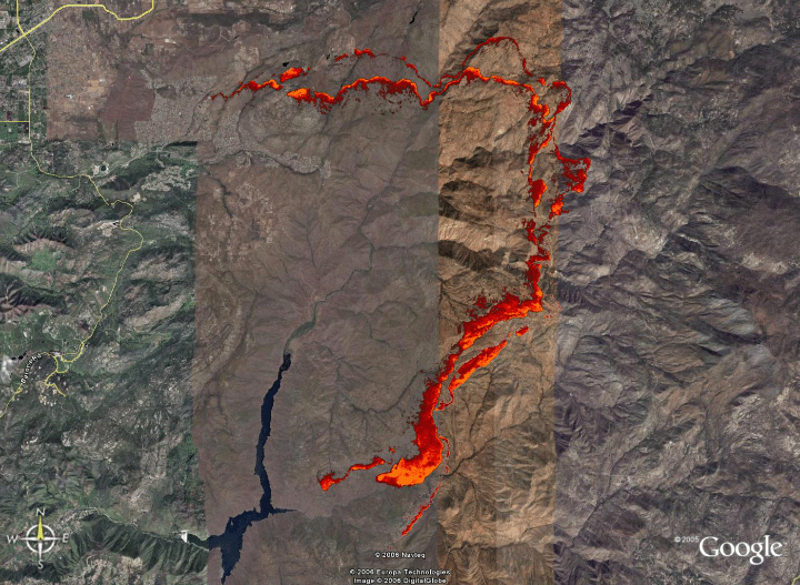
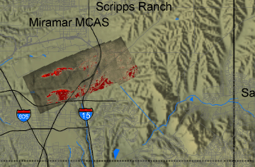
Cedar Fire Eastern Front, San Diego County, CA
26 October 2003 11:34 to 18:38
As viewed by the FireMapper™
Thermal-Imaging Radiometer
|
Click on the image above to view a larger JPEG image
(opens a new browser window)
Current Image: Thermal mosaic
Passes 6, 9, 17, 31, 29, 26, 25 over 51, 59, and 53/54
|
| |
|
|
Eastern front with repeat transects
from north to south
|
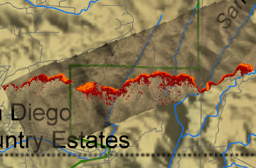
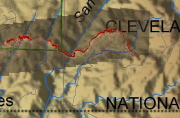
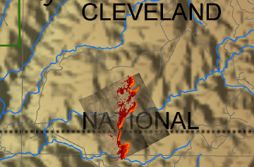
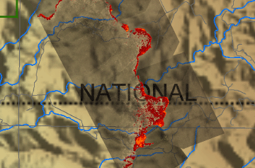
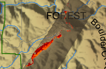
Image 1: Mosaic Overlay
Firespread series: Pass 06 at 11:34

View the Cedar Fire Pass 06 in Google Earth.
Locations approximate.
|
Click on the image above to view a larger JPEG image
(opens a new browser window) |
|
|
|
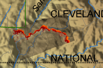
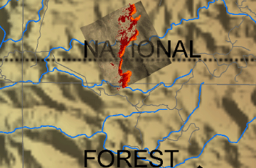
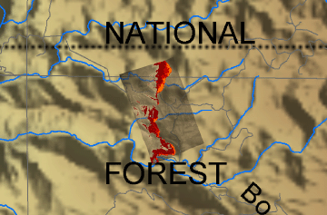
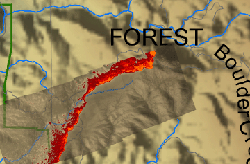
Image 1a: Mosaic Overlay
Firespread series: Pass 51 at 18:15
View the Cedar Fire Pass 51 in Google Earth.
Locations approximate.
|
Click on the image above to view a larger JPEG image
(opens a new browser window) |
|
|
|
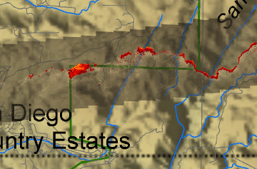
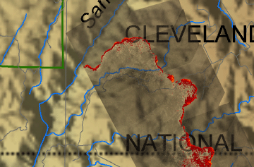
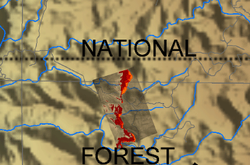
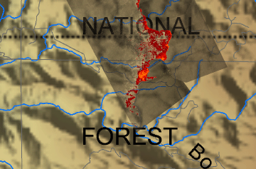
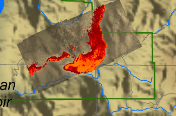
Image 2: Mosaic Overlay
Firespread series: Pass 09 at 12:01
View the Cedar Fire Pass 09 in Google Earth.
Locations approximate.
|
Click on the image above to view a larger JPEG image
(opens a new browser window) |
|
|
|
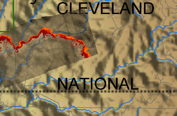
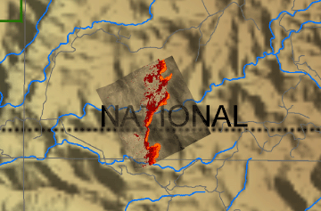
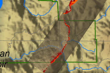
Image 2a: Mosaic Overlay
Firespread series: Pass 51 at 18:15
View the Cedar Fire Pass 51 in Google Earth.
Locations approximate.
|
Click on the image above to view a larger JPEG image
(opens a new browser window) |
|
|
|
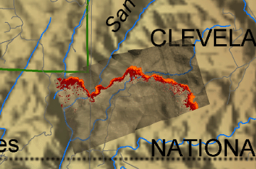
Image 3: Mosaic Overlay
Firespread series: Pass 09 at 12:01
View the Cedar Fire Pass 09 in Google Earth.
Locations approximate.
|
Click on the image above to view a larger JPEG image
(opens a new browser window) |
|
|
|
Image 3a: Mosaic Overlay
Firespread series: Pass 53, 54 at 18:22
View the Cedar Fire Pass 53, 54 in Google Earth.
Locations approximate.
|
Click on the image above to view a larger JPEG image
(opens a new browser window) |
|
|
|
Image 4: Mosaic Overlay
Firespread series: Pass 09 at 12:01
View the Cedar Fire Pass 09 in Google Earth.
Locations approximate.
|
Click on the image above to view a larger JPEG image
(opens a new browser window) |
|
|
|
Image 4a: Mosaic Overlay
Firespread series: Pass 17 at 12:41
View the Cedar Fire Pass 17 in Google Earth.
Locations approximate.
|
Click on the image above to view a larger JPEG image
(opens a new browser window) |
|
|
|
Image 5: Mosaic Overlay
Firespread series: Pass 17 at 12:41
View the Cedar Fire Pass 17 in Google Earth.
Locations approximate.
|
Click on the image above to view a larger JPEG image
(opens a new browser window) |
|
|
|
Image 5a: Mosaic Overlay
Firespread series: Pass 31 at 14:06
View the Cedar Fire Pass 31 in Google Earth.
Locations approximate.
|
Click on the image above to view a larger JPEG image
(opens a new browser window) |
|
|
|
Image 6: Mosaic Overlay
Firespread series: Pass 17 at 12:41
View the Cedar Fire Pass 17 in Google Earth.
Locations approximate.
|
Click on the image above to view a larger JPEG image
(opens a new browser window) |
|
|
|
Image 6a: Mosaic Overlay
Firespread series: Pass 53, 54 at 18:22
View the Cedar Fire Pass 53, 54 in Google Earth.
Locations approximate.
|
Click on the image above to view a larger JPEG image
(opens a new browser window) |
|
|
|
Image 7: Mosaic Overlay
Firespread series: Pass 31 at 14:06
View the Cedar Fire Pass 31 in Google Earth.
Locations approximate.
|
Click on the image above to view a larger JPEG image
(opens a new browser window) |
|
|
|
Image 7a: Mosaic Overlay
Firespread series: Pass 53, 54 at 18:22
View the Cedar Fire Pass 53, 54 in Google Earth.
Locations approximate.
|
Click on the image above to view a larger JPEG image
(opens a new browser window) |
|
|
|
Image 8: Mosaic Overlay
Firespread series: Pass 29 at 14:06
View the Cedar Fire Pass 29 in Google Earth.
Locations approximate.
|
Click on the image above to view a larger JPEG image
(opens a new browser window) |
|
|
|
Image 8a: Mosaic Overlay
Firespread series: Pass 59 at 18:38
View the Cedar Fire Pass 59 in Google Earth.
Locations approximate.
|
Click on the image above to view a larger JPEG image
(opens a new browser window) |
|
|
|
Image 9: Mosaic Overlay
Firespread series: Pass 26 at 13:37
View the Cedar Fire Pass 26 in Google Earth.
Locations approximate.
|
Click on the image above to view a larger JPEG image
(opens a new browser window) |
|
|
Image 9a: Mosaic Overlay
Firespread series: Pass 29 at 13:51
View the Cedar Fire Pass 29 in Google Earth.
Locations approximate.
|
Click on the image above to view a larger JPEG image
(opens a new browser window) |
|
|
|
Image 9b: Mosaic Overlay
Firespread series: Pass 59 at 18:38
View the Cedar Fire Pass 59 in Google Earth.
Locations approximate.
|
Click on the image above to view a larger JPEG image
(opens a new browser window) |
|
|
|
Image 10: Mosaic Overlay
Firespread series: Pass 25 at 13:26
View the Cedar Fire Pass 25 in Google Earth.
Locations approximate.
|
Click on the image above to view a larger JPEG image
(opens a new browser window) |
|
|
|
Image 10a: Mosaic Overlay
Firespread series: Pass 59 at 18:38
View the Cedar Fire Pass 59 in Google Earth.
Locations approximate.
|
Click on the image above to view a larger JPEG image
(opens a new browser window) |
|
|
|
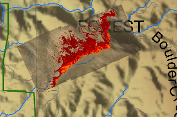
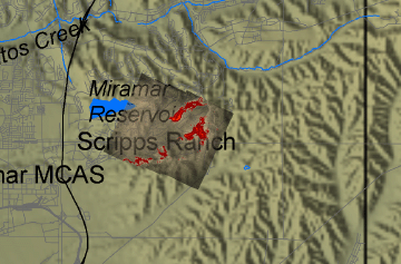
Southwest set of repeat transects (near Miramar)
|
Image 11: Mosaic Overlay
Firespread series: Pass 11 at 12:12
Entire Sequence:
View the Cedar Fire repeat coverage of this area:
Passes 11, 12, 14, 15, 17, 29, 31, 33, 34, 36 and 68/69.
|
Click on the image above to view a larger JPEG image
(opens a new browser window) |
|
|
|
Northwest set of repeat transects (near Poway)
|
Image 12: Mosaic Overlay
Firespread series: Pass 02 at 11:34
Entire Sequence:
View the Cedar Fire repeat coverage of this area:
Passes 2, 6, 9, 37 and 70.
|
Click on the image above to view a larger JPEG image
(opens a new browser window) |