Cathedral Peak Fire,
Sweet Grass & Still Water counties, MT
23 August 2003
As viewed by the FireMapper™ Thermal-Imaging
Radiometer
Images were collected from the PSW Airborne
Sciences Aircraft and disseminated in part by satellite
communications in near-real time. FireMapper measures the
radiance of emitted thermal-infrared light, which readily
penetrates smoke. False-color images shown here depict
the apparent surface temperature (in Celsius) as estimated
from radiance and a simple black-body model. Warmer tones
represent recent or active combustion; areas of gray are
cooling ash or warm bare ground (see chart below). Low
temperatures of unburned forest and cool ground are shown
in green. Images have been geographically referenced. Vertical
exaggeration in 3-d views is 1.5 to one unless otherwise
noted.
|
| |
|
Location Map
Cathedral Peak Fire (courtesy of
www.geomac.gov). Active
fires are labeled in white.
|
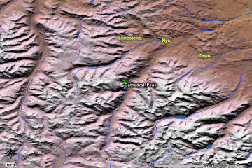
Click on the image above to view a larger JPEG image |
|
|
Fire Imagery
|
The following color-coded images depict apparent ground
surface temperatures in Celsius. Roads, streams, and
the text in the background are from a 1:24,000 topographic
map.
|
| |
|
|
Image 1:
Ground surface temperatures as viewed from above at 11.9
micrometers wavelength on 23 August 2003, at 17:02 and
20:52 MDT.
DISCLAIMER: This image is preliminary (posted
03-Mar-2005 15:11
). Further postings will complete the view of the fire area.
Check back regularly for the latest update.
|

Click on the image above to view a larger JPEG image |
|
|
|
Image 2:
Topographic view as seen from the east of Image 1. |
Click on the image above to view a larger JPEG image |
|
|
|
Image 3:
Topographic view as seen from the west of Image 1. |
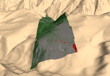
Click on the image above to view a larger JPEG image |
| |
|
Narrative
from the INCIDENT MANAGEMENT SITUATION REPORT
SATURDAY AUGUST 23, 2003 - 0800 MDT. (Courtesy of www.nifc.gov.) |
|
CATHEDRAL PEAK, Custer National Forest. A Type
1 Incident Management Team (Humphrey) is
assigned. This incident, comprised of the Cathedral Peak
and Salderbalm fires, is in timber 10
miles south of Nye, MT. Early morning red flag conditions
resulted in a growth of about 70 acres
on the Salderbalm fire. Running and crowning were observed.
The Cathedral Peak fire remained
fairly quiet. Structure protection is in place for 50 residences
and one commercial property.
|
 Piper Navajo remote sensing aircraft


