Mineral/Primm
Fire, Missoula County, MT
17 August 2003
As viewed by the FireMapper™
Thermal-Imaging Radiometer
Images were collected from the PSW Airborne
Sciences Aircraft and disseminated in part by satellite
communications in near-real time. FireMapper measures the
radiance of emitted thermal-infrared light, which readily
penetrates smoke. False-color images shown here depict
the apparent surface temperature (in Celsius) as estimated
from
radiance and a simple black-body model. Warmer tones represent
recent or active combustion; areas of gray are cooling
ash
or warm bare ground (see chart below). Low temperatures
of unburned forest and cool ground are shown in green.
Images have been geographically referenced. Vertical exaggeration
in 3-d views is 1.5 to one unless otherwise noted.
|
| |
|
Location Map
Mineral/Primm complex (courtesy of
www.geomac.gov). Active fires are labeled in white. |
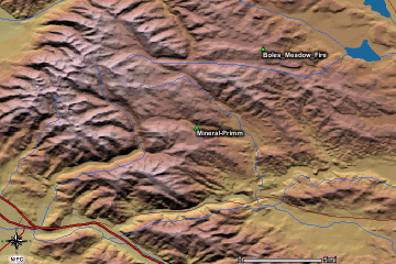
Click on the image above to view a larger JPEG image |
| |
|
Fire Imagery
|
The following color-coded images depict apparent ground surface temperatures
in Celsius. Roads, streams, and the text in the background are from
a 1:100,000 topographic map.
|
| |
|
|
Image 1:
Ground surface temperatures as viewed from above at 11.9
micrometers wavelength on 17 August 2003, at 23:11 and
23:18 UMT.
|
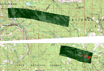
Click on the image above to view a larger JPEG image |
|
Image 2:
Image from above, on a shaded relief map.
|
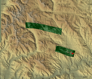
Click on one of the 2 image strips above to view a larger JPEG
image of that strip |
Image 3:
Topographic view as seen from the southeast of Image 1. |
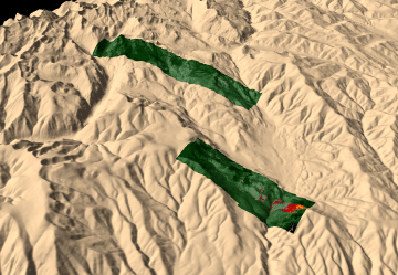
Click on the image above to view a larger JPEG image |
|
|
|
| |
|
| |
|
Narrative
from the INCIDENT MANAGEMENT SITUATION REPORT
SUNDAY AUGUST 17, 2003 - 0800 MDT. (Courtesy of www.nifc.gov.) |
|
MINERAL/PRIMM, Southwestern Land Office, Montana
Department of Natural Resources &
Conservation. A Type 1 Incident Management Team (Bennett)
is assigned. The fire is in timber,
19 miles northeast of Missoula, MT. Strong west winds caused
torching and crowning along ridge
tops and spotting up to ¼ mile. The fire continued
to flank towards Gold Creek.
|
 Piper Navajo remote sensing aircraft


