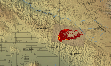
Woodhouse Fire, Riverside County
5 October 2005
As viewed by the FireMapper™
Thermal-Imaging Radiometer
|
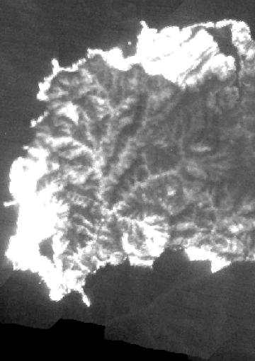
Thermal Mosaic
Plan view of fire shown on shaded relief map.

View this image of the Woodhouse Fire as a Google Earth overlay.
|
Click on the image above to view a larger Zoomify image
or view the JPEG version
(opens a new browser window) |
|
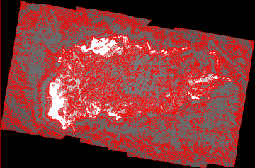
Current
Image: Thermal mosaic
Ground surface temperatures as viewed from above at 11.9 micrometers wavelength
on 5 October 2005, at 5:11 pm PDT. |
|
|
Shapefile:
Download a zip file containing the thermal data in Shapefile format |
Click on the image above to view a larger JPEG image
(opens a new browser window) |
|
|
|
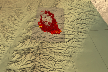
Image 1: Mosaic
Topographic view from west. |
Click on the image above to view a larger JPEG image
(opens a new browser window) |
|
|
|
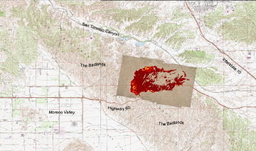
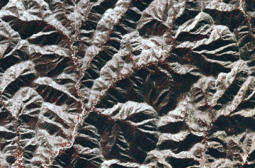
Image 2: Mosaic
Plan view of fire shown on 1:24k topo map (DRG). |
Click on the image above to view a larger JPEG image
(opens a new browser window) |
|
|
|
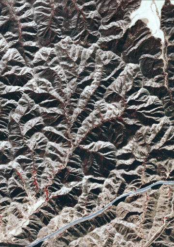
Image 3: Relief
This portion of the DEM from the fire area has been inverted, so that the lower elevations are brighter, and the ridgetops are darker.
This depiction correlates with the expected fuel loading- heavy vegetation on the lower slopes, heaviest in the riparian areas, and sparse on upper slopes and ridgetops.
Open both Image 2 and Image 3, then tab between them to perform a visual survey of the correlation between relative elevation and residual heat, where elevation is a proxy for fuel load. |

Click on the image above to view a larger JPEG image
(opens a new browser window) |
|
|
|
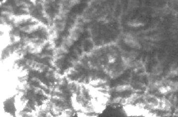
Image 4: Thermal
The same area as in the inverted DEM above, showing the thermal in grayscale.
The bright pixels interior to the fire indicate residual burning and/or lingering heat from intense combustion- a result of higher fuel loading in those areas.
Open both Image 3 and Image 4, then tab between them to perform a visual survey of the correlation between relative elevation and residual heat, where elevation is a proxy for fuel load. |
Click on the image above to view a larger JPEG image
(opens a new browser window) |
|
|
Image 5: NAPP photo
The same area as in the thermal above; the vegetation appears red in this Color IR photo from Sept. 30, 1996.
It is evident that the north-facing slopes (darker areas) support more vegetation than the south-facing slopes (lighter areas) and that most vegetation is found in the stream bottoms.
|
Click on the image above to view a larger JPEG image
(opens a new browser window) |
|
|
|
Image 7: NAPP photo close-up
Chaparral shrub growth as imaged 9 years ago.
Link to Google Local satellite image of this area!
(Probably more recent, but still pre-fire)
|
Click on the image above to view a larger JPEG image
(opens a new browser window) |
|
|
|
Image 8: Thermal close-up
Open both Image 7 and Image 8, then tab between them to perform a visual survey of the correlation between terrain aspect and residual heat, where aspect is a proxy for fuel load.
|
Click on the image above to view a larger JPEG image
(opens a new browser window) |
|
|
|
Image 9: Relief & Thermal
The inset charts show the pixel values along the transect line, starting at the north end. Both charts depict 3 small ridges (actually gullies), then 2 larger ones. The asymmetry in the thermal may be due to higher fuel loads on the north slopes. |
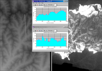
Click on the image above to view a larger JPEG image
(opens a new browser window) |
Weather conditions at time of data collection:
from NOAA ROMAN system. |
Past Weather Conditions for BNTC1
Observations prior to selected time: October 05, 2005 - 18:00 PDT
Weather Conditions at October 5, 2005 - 17:10 PDT
|
17:10 |
24 Hour Max |
24 Hour Min |
| Temperature |
78.0° F |
80.0 at 16:10 |
64.0 at 5:10 |
| Dew Point |
5.6° F |
14.3 at 20:10 |
-1.2 at 10:10 |
| Wet Bulb Temperature |
48.8° F |
49.4 at 16:10 |
42.7 at 5:10 |
| Relative Humidity |
6% |
12 at 19:10 |
5 at 10:10 |
| Wind Speed |
12 mph from E |
17 at 11:10 |
9 at 20:10 |
| Wind Gust |
35 mph |
45 at 13:10 |
26 at 20:10 |
| Pressure |
27.10 in |
27.17 at 9:10 |
27.09 at 18:10 |
| Sea Level Pressure |
29.72 in |
29.86 at 7:10 |
29.72 at 17:10 |
| Altimeter |
29.88 in |
29.96 at 9:10 |
29.87 at 18:10 |
| 1500 m Pressure |
24.93in |
25.00 at 9:10 |
24.93 at 18:10 |
| Solar Radiation |
300.0 W/m*m |
840.0 at 13:10 |
0.0 at 20:10 |
| Fuel Temperature |
78.0° F |
87.0 at 15:10 |
62.0 at 5:10 |
| 10 hr Fuel Moisture |
0 gm |
0 at 18:10 |
0 at 18:10 |
| Battery voltage |
13.30 volt |
13.30 at 9:10 |
12.10 at 6:10 |
|


