|
|
|
 |
Fire Science: Wildfire Monitoring and Prediction
|
|
|
|
|
|
Warm Fire, Coconino County, AZ
20 June 2006
As viewed by the FireMapper 2 ™
Thermal-Imaging Radiometer
-data collected by the Bureau of Land Management aircraft N30W-
|
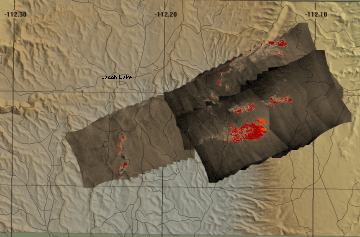
Thermal Mosaic
Plan view of fire shown on shaded relief map.

View this image of the Warm Fire as a Google Earth overlay.
Local Area Map
for this fire (Google Maps)
Incident information from InciWeb
|
Click on the image above to view a larger Zoomify image
(opens a new browser window) |
|
Current
Image: Thermal mosaic
Ground surface temperatures as viewed from above at 11.9 micrometers wavelength
on 20 June 2006, at 6:11 to 6:15 pm MDT. |
|
This imagery shows variation in background temperature because the instrument temperature had not yet stabiized after the aircraft reached altitude. |
|
|
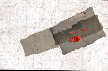
Image 1: Mosaic
Plan view of fire shown on 1:24k topo map (DRG). |
Click on the image above to view a larger JPEG image
(opens a new browser window) |
|
| |
FireMapper™ has
been developed through a Research Joint Venture with Space Instruments,
Inc., and support from the National Fire Plan, Forest Service International
Programs, the U.S. Department of Agriculture, the Joint Fire Sciences Program, and the U.S. Agency
for International Development.
|