Discriminating Retardant Drops in Thermal Imagery
19 June, 2002
This page presents a short-interval sequence of images showing the delivery of fire retardant from an airtanker near the ground.
The series of close-up images are all registered, and can be view as a sequence of overlays by clicking to open each JPEG in it's own window, then tabbing between them.
|
Image 1: Pass 19 Overview
Image #48
from the IR3 camera
(11.5 to 12.3 micrometres wavelength) at 2:31:43 pm.
Temperatures over 60 C have been colored from dark red to orange to yellow to white to represent increasing values. The grayscale tones represent ambient temperatures below 60 C of the unburned vegetation, rock and bare ground. The coolest (dark) values are found in the riparian zones and under recent fire retardant drops.
Background image (green and magenta) is a post-fire image from the following day. |

Click on the image above to view a larger JPEG image |
| |
|
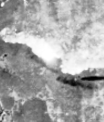
Image 2:
Image #42
from the higher resolution VA camera
(0.615 to 0.685 micrometres wavelength) at 2:31:40 pm.
Note the plane making a drop of aerially delivered fire retardant. The trailing plume and shadow are clearly seen in this visible red band image. |
Click on the image above to view a larger JPEG image |
| |
|
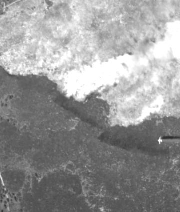
Image 3:
Image #43
from the IR4 camera
(8.1 to 12.3 micrometres wavelength)
at 2:31:40 pm.
The trailing plume is clearly seen in this broad-band thermal IR band image. |
Click on the image above to view a larger JPEG image |
| |
|
Image 4:
Image #44
from the SWIR camera (1.5 to 1.65 micrometres wavelength)
at 2:31:40 pm.
Note the plane making a drop of aerially delivered fire retardant. The trailing plume is clearly seen in this short wave IR band image. |
Click on the image above to view a larger JPEG image |
| |
|
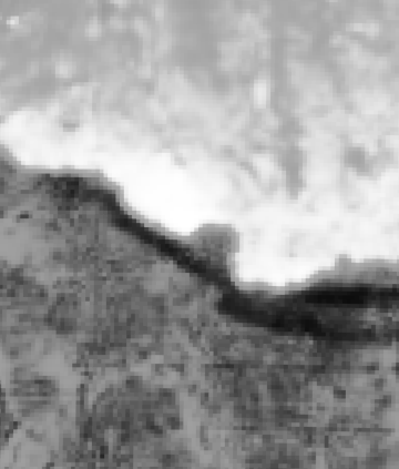
Image 5:
Image #48
from the IR3 camera
(11.5 to 12.3 micrometres wavelength) at 2:31:43 pm. |
Click on the image above to view a larger JPEG image |
| |
|
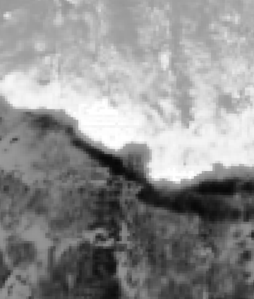
Image 5a:
Image #48
from the IR3 camera
(11.5 to 12.3 micrometres wavelength) at 2:31:43 pm.
Yellow lines designate areas of cooler pixels. |
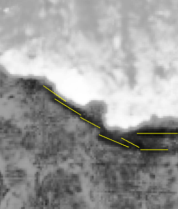
Click on the image above to view the JPEG image
|
| |
|
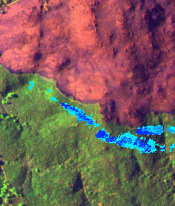
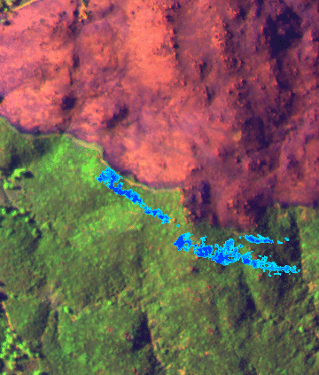
Image 5b:
False-color image from the following day with additional cool blue pixels designating areas of retardant drops (classified from the VA, VB, SWIR, TIR bands).
13 shades of blue highlight the cool pixels in the area of recent fire retardant drops. The blue shaded area is at least 10 C below the surrounding area.

View this Troy Fire image in Google Earth.
Locations approximate.
|
Click on the image above to view the JPEG image
|
| |
|
Image 6:
Image #49
from the higher resolution VA camera
(0.615 to 0.685 micrometres wavelength) at 2:31:46 pm.
Note the plane has completed the drop of aerially delivered fire retardant, and is pulling up and away. The plane and shadow, as well as the strips of retardant on the ground, are clearly seen in this visible red band image. |
Click on the image above to view a larger JPEG image |
| |
|
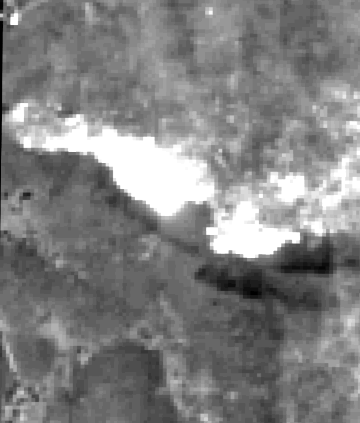
Image 6a:
Image #49
from the higher resolution VA camera
(0.615 to 0.685 micrometres wavelength) at 2:31:46 pm.
Yellow lines designate areas of darker pixels. |
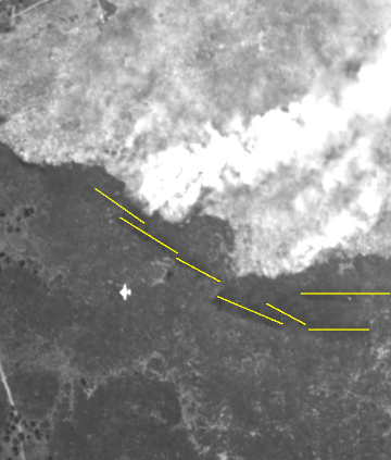
Click on the image above to view the JPEG image
|
| |
|
Image 6b:
False-color image from the following day with additional cool blue pixels designating areas of retardant drops (classified from the visible band).
13 shades of blue highlight the cool pixels in the area of recent fire retardant drops. The blue shaded area is at least 10 C below the surrounding area. |
Click on the image above to view the JPEG image
|
| |
|
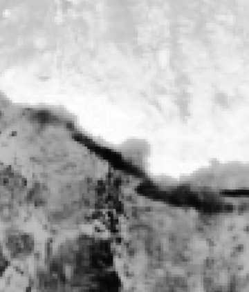
Image 7:
Image #50
from the IR4 camera
(8.1 to 12.3 micrometres wavelength)
at 2:31:44 pm. |
Click on the image above to view a larger JPEG image |
| |
|
Image 8:
Image #51
from the SWIR camera (1.5 to 1.65 micrometres wavelength) at 2:31:46 pm.
Note the plane has completed the drop of aerially delivered fire retardant, and is pulling up and away. |
Click on the image above to view a larger JPEG image |
| |
|
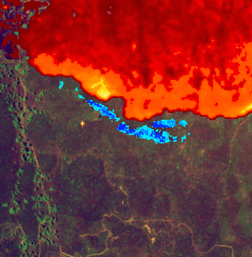
Image 9:
Image #48
from the IR3 camera
(11.5 to 12.3 micrometres wavelength) at 2:31:46 pm.
Temperatures over 60 C have been colored from dark red to orange to yellow to white to represent increasing values.
Background image (green and magenta) is a active-fire image from 2:31:46 pm.
Cool blue pixels designate areas of retardant drops (classified from the VA, VB, SWIR, TIR bands).
View this Troy Fire image in Google Earth.
Locations approximate.
|
Click on the image above to view a larger JPEG image |
| |
|
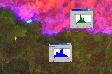
Image 10:
Temperatures
from the IR4 camera
(8.1 to 12.4 micrometres wavelength) at 2:31:46 pm.
Temperatures in 2 adjacent areas have been charted. The lower blue box is in the area of the recent retardant drop; the upper green box is surface at ambient. The retardant drop temperatures range from 17 to 26 C; the ambient surface temperatures range from 28 to 51 C.
Background image (green and magenta) is an active-fire image from 2:31:46 pm. |
Click on the image above to view a larger JPEG image |
| |
|
Weather Conditions for MLGC1
June 19, 2002 - 22:00 GMT
|
22:00 |
24 Hour Max |
24 Hour Min |
| Temperature |
84.0° F |
84.0 at 21:00 |
54.0 at 6:00 |
| Dew Point |
37.3° F |
41.4 at 16:00 |
28.2 at 0:00 |
| Relative Humidity |
19% |
53 at 10:00 |
16 at 22:00 |
| Wind Speed |
4 mph from SE |
6 at 22:00 |
0 at 4:00 |
| Wind Gust |
16 mph |
17 at 22:00 |
4 at 7:00 |
| Fuel Temperature |
93.0° F |
98.0 at 21:00 |
51.0 at 6:00 |
| Precipitation accumulated since midnight: 0.00", in 24 hours: 0.00" |
|


