|
Western San Bernardino National
Forest
3 December 2002
As viewed by the FireMapper™ system
in reflected red, near-InfraRed and thermal-InfraRed light
Images were collected
from the PSW Airborne Sciences Aircraft flying over the
area near Lake Arrowhead.
The enlarged JPEG images have .75-meter resolution.
|
The forests in the San Bernardino Mountains and the
Peninsular Ranges are seriously drought stressed. In addition,
some have diseases (dwarf mistletoe, annosus root disease)
which also cause severe stress. Stressed trees can't produce
enough resin to protect against pathogens. Examples of these
include the California flatheaded borer, mountain pine beetle,
red turpentine beetle, Jeffrey-pine beetle and western pine
bark beetle. The fir engraver attacks fir trees while the
Ips beetle is a scavenger that attacks the tops of trees,
along with slash and seriously distressed trees.
Trees in the San Bernardinos are subject to drought, air
pollution, and complexes of pests, not just beetles. Deciduous
species are affected the same as the coniferous species;
black oaks there are suffering from drought stress and also
defoliation by the fruit-tree leafroller.
(Entomologist Dr. Laura Merrill, personal
communication)
More
information on Insects and Forest Diseases
|
|
|
|
|
Location Map:
Shaded relief map of the Silverwood Lake, Lake Arrowhead,
Butler Peak, San Bernardino N., Harrison Mountain, and Keller
Peak quadrangles.
The color overlay shows the area of processed imagery.
|
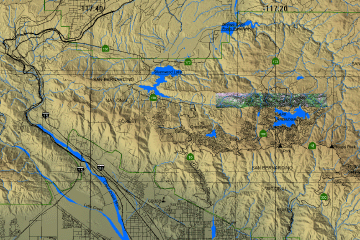
Click on the image above to view a larger JPEG image
|
|
Forest Imagery
|
In the following false-color images healthy vegetation
appears green and recently killed conifers appear magenta.
(These RGB images depict reflected red light
at 650 nm in red and blue, reflected near-IR
light at
850 nm in
green.)
|
Image 1:
Image mosaic from north of Lake Arrowhead.
|
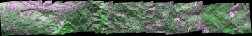
Click on the image above to open a new browser window, then click to zoom in on a portion of that image.
Maximum resolution is .75 meters.
|
Image 2:
Urban forest of the North Shore area near North Bay of Lake Arrowhead. This RGB image was acquired at 11:53 am, 3 December 2002. |
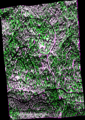
Click on the image above to view a larger JPEG image
|
Image 2a:
Topographic view from the southeast of Image 2.
|
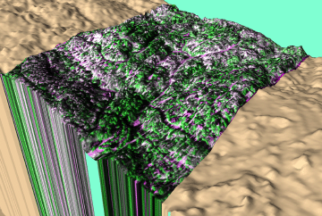
Click on the image above to view a larger JPEG image
|
| Compare this image with the earlier image |
|
| |
|
| |
|


