|
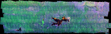
Vegetation mortality
survey,
San Bernardino National Forest
27 May 2003
As viewed by the FireMapper™
system
in reflected red, near-IR, and thermal IR frequencies
Images were collected
from the PSW Airborne Sciences Aircraft flying over the
area near Lake Arrowhead.
|
Click on the image above to view a full-resolution Zoomify image in a new browser window
|
| |
|
| |
| |
|
|
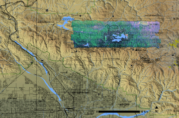
Location Map:
Shaded relief map of the Silverwood Lake, Lake
Arrowhead, Keller Peak, North San Bernardino, Hamilton
Mountain area. Color overlay shows area of processed
imagery.
|
Click on the image above to view a larger JPEG image in a new browser
window
|
| |
|
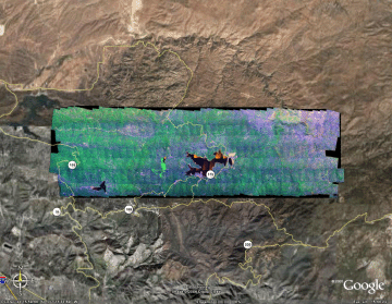
Image 1:
View a greatly reduced resolution version as displayed in Google Earth.

View this image as a Google Earth overlay
|
Click on the image above to view a larger JPEG image in a new browser window
|
| |
Healthy vegetation is bright green; stressed or dying
vegetation is orange-brown in this false-color depiction.
|
| |
(This RGB image shows reflected red light at 650 nm in
red, reflected NIR at 850 nm in green, and thermal IR at
10.5 um in blue.)
|
| |
|
Image 2:
Image of area near Cedarpines Park.
Go to page with more images from this set of low-altitude passes
|
Click on the image above to view a full-resolution Zoomify image in a new browser window
|
| |
Healthy vegetation is bright green; stressed or dying vegetation is orange-brown in this false-color depiction.
|
| |
(This RGB image shows reflected red light at 650 nm in red, reflected NIR at 850 nm in green, and thermal IR at 10.5 um in blue.)
|
| |
|
| |
|
 Piper Navajo remote sensing aircraft
