|
|
 2003 2003 |
 |
Piper Navajo remote sensing aircraft
Fire Science: Wildfire Monitoring and Prediction
|
|
Forest Mapping: Regional Map |
|
|

California
|
|
Local Area Map for this survey
All Imagery for this survey
|
Current Image: Partial mosaic
from April 27 and 30
|
Vegetation Imagery
|
These color-coded images depict apparent ground surface temperatures in Celsius.
The background image is a shaded relief map from 30-meter SRTM elevation data.
|
|
|
Crestline, Lake Arrowhead, Running Springs, Green Valley Lake, and Big Bear Lake
Map of the western San Bernardino mountains showing flight paths for data collection transects.
|
![]()
Click on the image above to view a larger GIF image of the map
|
|
|
Crestline, Lake Arrowhead, Running Springs, Green Valley Lake, and Big Bear Lake
Map of the western San Bernardino mountains showing flight paths for data collection transects.
|

Click on the image above to view a larger GIF image of the map
|
|
|
Cajon Pass on the west and Highway 38, Angelus Oaks, Barton Flats and Onyx Peak on the east
Map of the western San Bernardino mountains showing flight paths for data collection transects.
|

Click on the image above to view a larger GIF image of the map
|
|
|
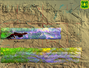
Lake Arrowhead
Map of the western San Bernardino mountains showing flight paths for data collection transects.
|

Click on the image above to view a larger GIF image of the map
|
|
|
Cuyamaca Rancho SP
Map of the western San Diego county showing flight paths for data collection transects.
|

Click on the image above to view a larger GIF image of the map
|
|
|
Crestline, Lake Arrowhead, Running Springs, Green Valley Lake, and Big Bear Lake
Map of the western San Bernardino mountains showing flight paths for data collection transects.
|

Click on the image above to view a larger GIF image of the map
|
|
|
Highway 38, Angelus Oaks, Barton Flats and Onyx Peak
Map of the western San Bernardino mountains showing flight paths for data collection transects.
|

Click on the image above to view a larger GIF image of the map
|
|
|
Crestline, Lake Arrowhead, Running Springs, Green Valley Lake and San Bernardino's Del Rosa neighborhood
Map of the western San Bernardino mountains showing flight paths for data collection transects.
|

Click on the image above to view a larger GIF image of the map
|
Cuyamaca Rancho State Park, etc.
Map of the San Diego mountains showing flight paths for data collection transects.
|

Click on the image above to view a larger GIF image of the map
|
|
|
FireMapper™ has
been developed through a Research Joint Venture with Space Instruments,
Inc., and support from the National Fire Plan, Forest Service International
Programs, the U.S. Department of Agriculture, the Joint Fire Sciences Program, and the U.S. Agency
for International Development.
|
